Originally posted by Starman
View Post
-
I hope this does not happen. -
yea, I don't like that one friggin bit. I guess I can pray its a slow 30" and not heavy rains. We got VERY close during Harvey. The water just ran out of places to go it came down so fastOriginally posted by Starman View PostComment
-
I'm in southwestern Houston Co, right on the river and we have had 5" in the last 10 days, but my parents are in eastern Walker Co. ( almost due south of us ) and haven't had .5".Originally posted by bloodstick View Post
Also I'm supposed to hunt Big Lake Bottom in Palestine sept 28th - oct 6th so Im hoping it stays to the west a little because I hear it can get nasty out that wayComment
-
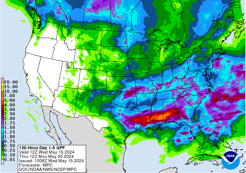
Latest from Jeff Lindner
Heavy rainfall event and flash flood threat this evening through Thursday for SE TX.
Flash Flood Watch will go into effect at 100pm today along and SE of a line from Wharton to Houston to Cleveland
Mid level low pressure system clearly noted in radar data from Houston and Corpus Christi continues to spin over the NW Gulf of Mexico about 150 miles south of Palacios. Numerous rainbands have formed in the last few hours across the NW Gulf of Mexico from Galveston Bay to over 200 miles off the upper TX coast and are rotating inland as far as Downtown Houston this morning. Brief heavy rainfall is likely with these bands this morning. Overall expect an increase in the frequency of these bands today and some potential for cell training in the Flash Flood Watch area which could produce a quick 1-2 inches of rainfall through this afternoon.
Mid level low pressure system and weak surface low/trough will begin to slowly lift northward into SE TX tonight through Wednesday night with numerous showers and thunderstorms expected. Best estimate track for this feature is inland over Matagorda/Brazoria Counties and then slowly NNE into Fort Bend and Harris Counties Wednesday and NNE toward Montgomery and San Jacinto Counties on Thursday. Global guidance has shifted ever so slightly eastward overnight with the track of this feature. Heavy rainfall both near the core or center of the low pressure area and within bands on the eastern and southern flank of the system will be likely. This becomes especially true late tonight into Wednesday as the 850mb moisture transport increases along with good low level inflow off the Gulf of Mexico. Moisture values will be extremely high during the period with PWS ranging from 2.35-2.65 inches which will support intense rainfall rates in any deep and sustained convective developments.
Rainfall Amounts:
Widespread rainfall amounts of 5-7 inches are expected over much of the area with isolated totals of 10-12 inches. Deep tropical moisture in place will support excessive hourly rainfall rates in deeper convection with rates of 1-3 inches possible. While grounds are dry, rainfall today will start to result in gradual saturation of the soil conditions and as rainfall totals increase over the next 24-36 hours run-off will also increase. Flash flooding will be possible under any areas of sustained training or cell clustering. Some of the higher resolution guidance is showing some indications of banding and potential for cell training late tonight into much of Wednesday over the region.
Hydro:
While watersheds are currently running below base flow, expected rainfall amounts will almost certainly lead to significant run-off once grounds become saturated. Rises on creeks and bayous to bankfull or above will be possible leading to more significant flooding. High short duration rainfall rates will lead to street flooding at times. Think most of Harris County can currently handle 5-6 inches of rainfall before significant bayou and creeks flooding would be a concern. However this greatly depends on the intensity of the rainfall rates and any breaks between the intense rainfall cells. Given the complexities in where any sort of training bands may become established yields little confidence on where any higher totals and larger flood threat would be.
WPC has placed portions of SE TX in a moderate risk for flash flooding today, Wednesday, and Thursday.
Comment
-
Thanks for the update.Comment
-
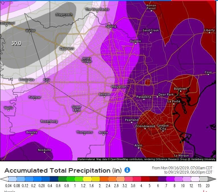
Dang I got family in Waller. You got a link to where that chart came from so I can forward it to them?Originally posted by Starman View Post
Sent from my SM-G955U using TapatalkComment
-
That chart comes from the linked site below. You can toggle between the other model forecast as well and see how they all differ. The latest Euro (0z Last Night) shifts the heavier rains more to east, similar to a lot of the other models. The image above was from yesterday. Don't take each model run verbatim as they will continually shift around, however, the main thing to take away is that ALL of the different models are showing wide spread rain across SETX, and some very high totals in isolated areas. Knowing where these really high, isolated amounts will fall is not known until training bands start to set up. Beaumont area seems under the gun right now.Originally posted by Neck View Post
Comment
-
Its already changed and saying Humble and Porter are in the 15-20" range nowOriginally posted by Neck View PostComment
-
Originally posted by ccbluewater View Post
Again, thanks for keeping the updates going. I know the info here is really all I pay attention to anymore.
The idiots on TV seem to be a waste of timeComment
-
Hope it moves a little more West. Mclennan and Mills sure need some rain.
Sent from my SM-T827V using TapatalkComment
-
Keep moving east!!!!!!!
Sent from my iPhone using TapatalkComment
-
We were flooded under in Anderson county from March til about July, please stay EAST and SOUTH!Comment
-
Saw this posting from KHOU this morning.... praying it’s wrong.
Sent from my iPhone using TapatalkComment
-
Yeah me too. I’m already at 5” from yesterday and today.Originally posted by axisbuck24 View PostComment
-
BRING IT ON!!! In a burn ban and no rain yetComment


Comment