Announcement

Collapse
No announcement yet.

tropical outlook

Collapse
X
 
  • Filter
  • Time
  • Show
Clear All
new posts

    #91
    Originally posted by TexasBob View Post
    Starting to look like Dorian may end up in the Gulf by the plots I see on storm2k. Any thoughts?


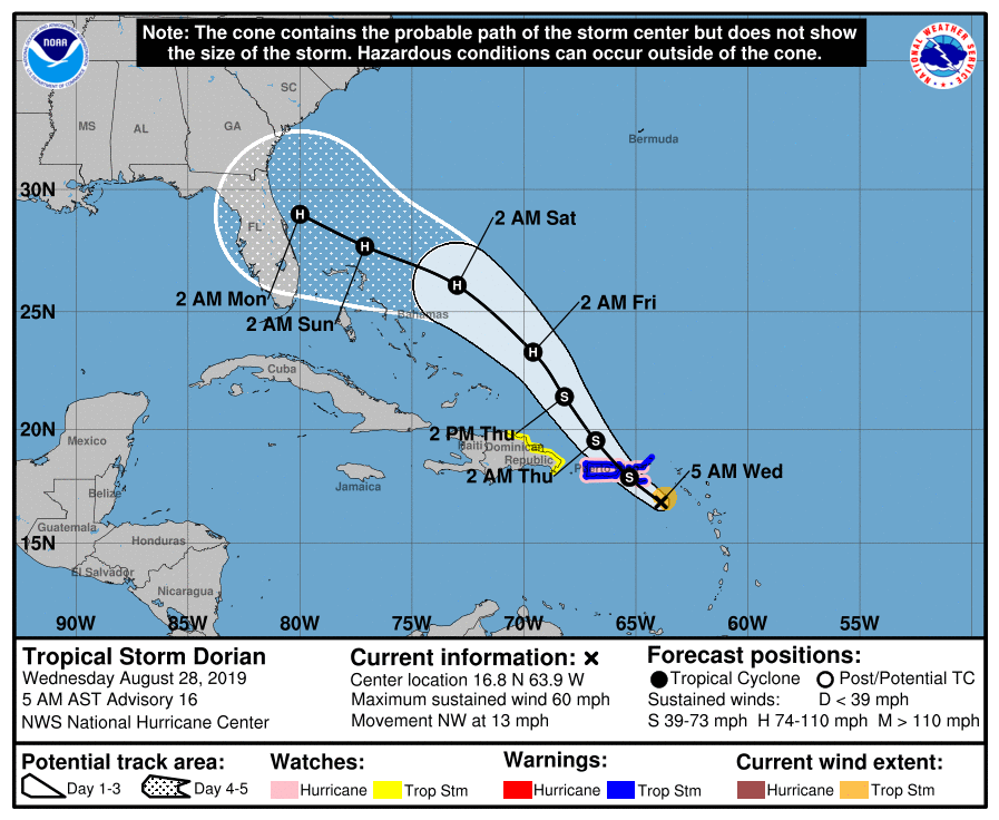
    I saw that this morning. Looks like it could cross FLA and head into LA


    Sent from my iPhone using Tapatalk

    Comment


      #92
      Dorian has been struggling, and isn't much at the moment. Might be slowly trying to get better organized but it isn't pretty by any means. Models have pretty good consensus on the track idea through the next couple days, but there are a ton of variables at play in regards to what Dorian might be after that. Could be a strengthening Storm heading towards the Bahamas/SE Florida or could completely die off. In next day or two there should be A LOT more known about what may happen, as it's interaction with, or the lack there of, with Hispaniola will have a lot of say in what happens down the road. It is called "the shredder" for a reason.

      After that, we will see. One thing that looks pretty consistent in the models is the ridge building back in, and shoving whatever is left back to the w/nw towards Florida.

      Hopefully, it doesn't sniff the gulf!

      Comment


        #93
        Originally posted by ccbluewater View Post

        Hopefully, it doesn't sniff the gulf!
        Beat me to it!

        Comment


          #94
          Well 24hrs can certainly change the outlook. Yesterday, Dorian getting ripped apart was a possibility, and NHC only projected a TS threat to Florida. NHC now projecting a Major Hurricane threat to Florida Sunday/Monday. Still a lot of uncertainty in the models, and each cycle of runs tweaks things a bit, and that likely wont change until later this week. Still could end up in the Gulf, but I have a hard time seeing it reach the Western Gulf/This area at this time. Keep an eye on the NHC, or your weather service just to be sure.

          Comment


            #95
            Good morning. Most of the area remained dry on Tuesday, but there were some sneaky strong showers and thunderstorms in the Clear Lake area that dropped as much as 2-3 inches of rain over a few loca…


            The “unnamed feature” seems a bit interesting.


            Sent from my iPhone using Tapatalk

            Comment


              #96
              That is the Upper Level Low that was originally thought to be putting some shear into Dorian and keeping it weak. As it traverses W/SW, and Dorian is moving more north & further east then thought, it will not have as much of an effect on Dorian.

              The latest model runs are going now, and the 12z Icon will raise some eyebrows. Not that it is super reliable, but it is sticking to its guns in regards to Dorian getting into the GOM, and is also closing off a possible system in the Western Gulf late this weekend/into next week.

              Comment


                #97
                For those like me that grew up looking at picture books instead of reading.
                Attached Files

                Comment


                  #98
                  Originally posted by Man View Post
                  For those like me that grew up looking at picture books instead of reading.
                  Thank you sir!

                  Comment


                    #99
                    Originally posted by Man View Post
                    For those like me that grew up looking at picture books instead of reading.


                    [emoji1374]


                    Sent from my iPhone using Tapatalk

                    Comment


                      We now have Hurricane Dorian for those interested. Any stock in that Icon model run CCbluewater? Doesn't give me the warm fuzzies but that's a looong way out, and not a top tier model I know.

                      Comment


                        labor day and hurricanes
                        Last edited by waterdog; 08-28-2019, 01:44 PM.

                        Comment


                          Dang Florida gonna get slapped in the face.... TWICE!

                          Comment


                            Looking potent this afternoon. Looks to be a serious situation in the coming days for Florida.


                            More up to date model plot. I hate these spaghetti plots but you guys like pictures!


                            Note the Euro, Euro Ensemble Mean, GFS Ensemble Mean, UK, CMC, HWRF, & Icon(not pictured) all show the more southerly crossing across the peninsula, and the further west 2nd landfall. Trend today is definitely South(first landfall) & west once in GOM. Likely will continue to flip flop. Still think it would be very unlikely for this to make it to TX, but can't ignore the possibility. *I am not a pro-met, and these are my thoughts alone*

                            Comment


                              Yep here in jacksonville now. Ready to get outta here friday

                              Comment


                                Was headed to Key west for a buddies 30th, doesn't look like that is happening anymore.

                                Comment

                                Working...
                                X