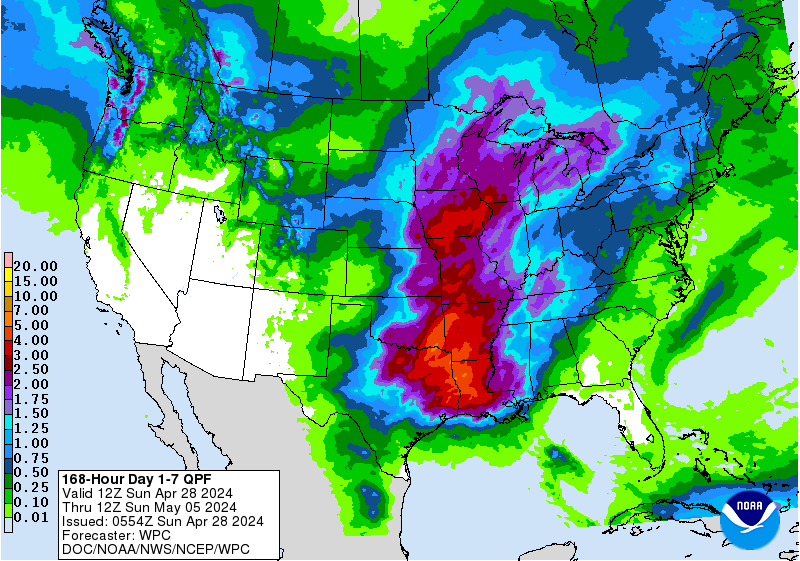
Definitely not look like as much rain as some of the models were showing yesterday for SETX & Central TX at the moment. 7 Day QPF chart included. Lots of uncertainty on where it goes AFTER coming ashore which is changing rainfall amounts nearly every run.
Latest from Jeff Lindner with HCFCD as well. High chance of tropical cyclone formation in the Gulf of Mexico this week
Residents along the US Gulf coast from MS to TX should closely monitor the progress of this system
The tropical wave over the southern Bahamas extending southward to the northern coast of Cuba has shown some limited degree of organization in the last 24 hours with deepening bursts of convection. However upper level winds continue to result in strong shear across the wave axis and overall disorganization of the system The wave is moving toward the W to WNW at 10-15mph and will be moving toward the FL Keys and southern FL today and Monday and then into the eastern Gulf of Mexico late Monday into Tuesday. Once in the Gulf of Mexico upper level conditions should become increasingly favorable as shear relaxes allowing thunderstorms to become more concentrated and likely a defined surface low pressure system to form.
Global forecast models have come into better agreement with the forming system moving fairly quickly WNW to NW toward coastal Louisiana by Wednesday and then inland on Wednesday night and Thursday with a slowing of forward speed. However many of the global ensemble members continue to indicate a more westward motion to the track near/along the Louisiana coast a high pressure over the SE US builds westward. Without any sort of defined low level center it is difficult to put much confidence in any of the model solutions at this time and uncertainty on track and intensity remain high.
There’s definitely a cat 5 Hurricane rolling into Dallas at 6:30 pm tomorrow night!
Haven’t watched any of the game but just saw the half time score after bird hunting.
When’s this current tropical depression expected to leave Arlington?
Haven’t watched any of the game but just saw the half time score after bird hunting.
When’s this current tropical depression expected to leave Arlington?
Haven’t watched any of the game but just saw the half time score after bird hunting.
When’s this current tropical depression expected to leave Arlington?


 hahaha
Comment